Ellesmere Island 2015
Expedition Ellesmere Island - as far north as the ice situation will allow. Where most ships will turn south into the heart of the Northwest Passage, we turned north into the fjords of Ellesmere Island and Axel Heiberg Island. This region is rarely visited due to its remote location and also due to the usually quite heavy sea ice present.
Greenland
Our charter flight with Air Greenland brought us directly to the former US Air Force Base in Kangerlussuaq (Greenland). With a long runway and a sheltered location, Kangerlussuaq is the only airport in Greenland served by large jet airplanes. Therefore, if you travel to Greenland, your first stop will usually be Kangerlussuaq. The small service town is located at the end of Søndre Strømfjord, about 180km (approx. 110 miles) away from the often stormy waters of Baffin Bay. While this might be ideal for air traffic, the location is a bit less ideal for ships. The last few miles of the fjord are extremely shallow, preventing ships from getting close to shore. Therefore, everything, including baggage, ship supplies, food, and passengers, has to be hauled back and forth using small boats.
Upon arrival, we took a short tour of the surrounding hills with some really old busses. The landscape around Kangerlussuaq is quite plain and the purpose of this tour most likely was to have some time to get MS Hanseatic, our home for the next three weeks, ready.
In the evening, we left Kangerlussuaq and sailed towards Baffin Bay. The passage through Søndre Strømfjord took up most of the night and we were entering Baffin Bay in the early morning hours. The steep cliffs of the fjords are billions of years old and are therefore some of the oldest rocks on earth.
Baffin Island
After a rainy and quite stormy day at sea on Baffin Bay, we arrived in Clyde River the next day. Usually, the first port of call in Canada for foreign ships is Pond Inlet, further north. Therefore, Clyde River doesn‘t receive that many ships. In fact, MS Hanseatic has been the first passenger vessel to call here for three years. The locals were really excited about our visit, and so were we. Clyde River has only around 1.000 inhabitants, but has a surprisingly elaborate infrastructure: there is a supermarket, a small hospital, a fire department and even an indoor ice hockey rink. After a short walk through town, we enjoyed an interesting show of traditional and modern Inuit dances and songs by the people of Clyde River. It‘s amazing how similar some of the dances are compared to what we had seen a year ago in the Russian Arctic. After this warm welcome in Canada, we spent the afternoon cruising with our Zodiac boats in nearby Clyde Inlet.
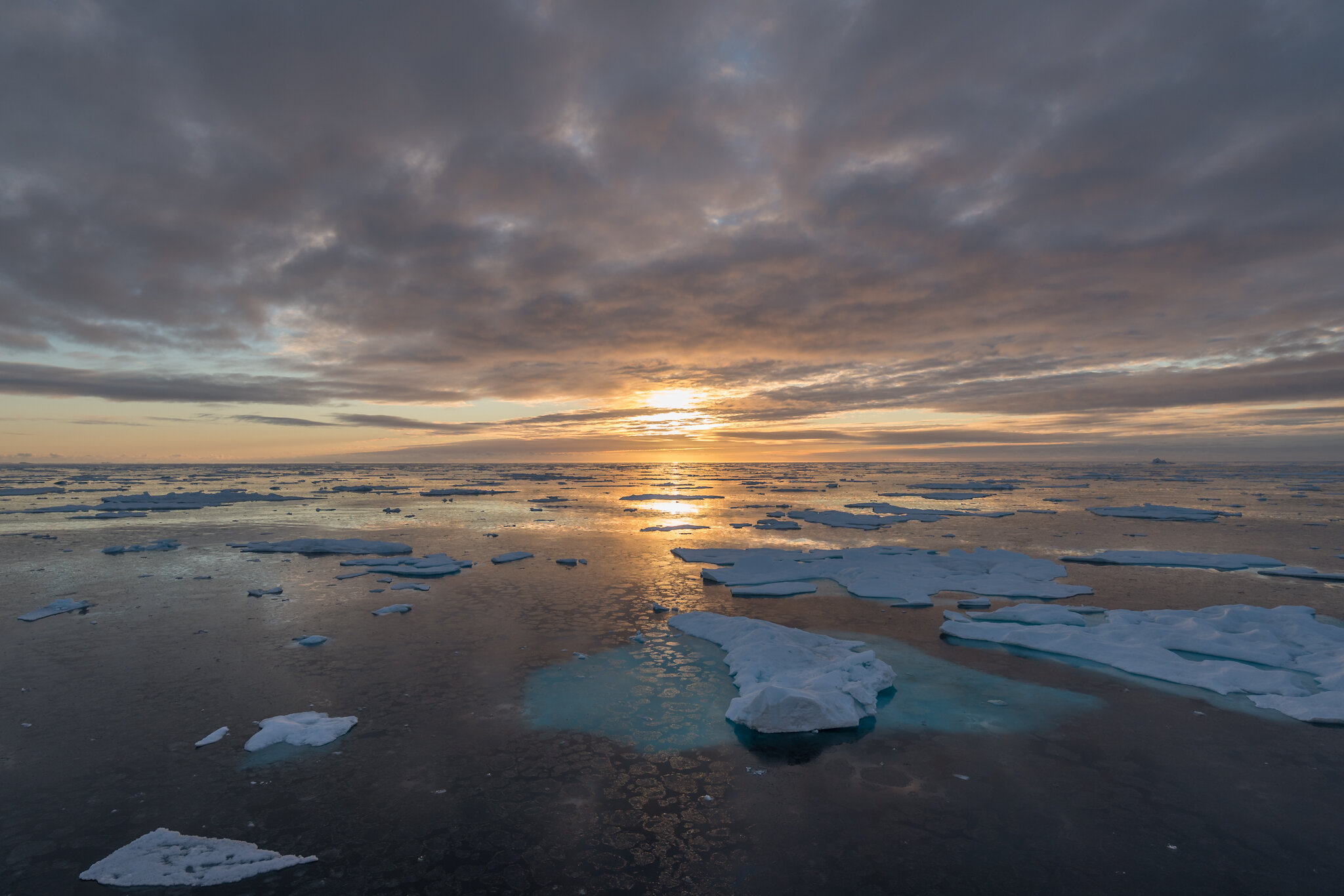
The next day started with a very familiar sound: MS Hanseatic crashing into an ice floe. But since it was only 3 a.m., we decided to ignore this noise, knowing that the ship had an reinforced hull for exactly these kind of encounters. At 5 a.m., we noticed the sun starting to peak through our blackout curtains. We quickly got dressed and headed out onto the open decks. What a morning! As the sun was rising, the sky glowed in colors that you can only experience in the Arctic. And since the temperature had dropped below freezing, a thin layer of ice had formed on the water.
On our way into Sam Ford Fjord, we discovered a polar bear mother with her two cubs feasting on a seal. They were quite far away, but we obviously didn‘t want to bother them, and therefore didn‘t approach them. In the afternoon, we went ashore next to a glacier, that had probably once been reaching all the way to the water. With the ice receding, we could now walk and climb onto the glacier moraine. After this exciting day, we sailed towards the open waters of Baffin Bay once again. We reached Baffin Bay in the middle of the night, when our captain set our course north towards the northernmost town of Baffin Island, Pond Inlet.
Pond Inlet is somewhat larger then Clyde River, but is still a small settlement. Here, you have two supermarkets, a motel and even an indoor miniature golf course. Towns in Greenland are always colorful and picturesque. In comparison, towns in the Canadian Arctic are more utilitarian. Here, again, the locals have prepared a nice display of their traditions in the surprisingly large town hall. Pond Inlet was our last stop in civilization for at least ten days. In anticipation of the days ahead, we sailed into the sunset in Eclipse Sound.
Hell Gate or Cardigan Strait?
To get to Jones Sound, just south of Ellesmere Island, we had to sail into Baffin Bay, again. This time, with strong winds and high waves, the short passage on open water was not too pleasant. However, as soon as we entered Jones Sound, the sea was a calm as a lake again. We could even cruise around the many ice floes with our Zodiacs, enjoying the Arctic sun. What started as a bumpy ride on Baffin Bay, turned into a wonderful expedition day.
The next day was decision day for our trip to Ellesmere Island. Between Devon Island and Ellesmere Island lays North Kent Island, dividing the entrance to Norwegian Bay into two narrows. To enter the fjords further north, you have to sail through either Cardigan Strait or Hell Gate, both known for their usually challenging ice situation. MS Hanseatic has a reinforced hull but is no icebreaker. Therefore, she could get stuck in the ice.
The ice charts clearly showed that Hell Gate was completely blocked with old ice. Cardigan Strait was mostly open. However, we not only needed to pass one of these narrows to get into the fjords, but also to get out a few days later. Getting stuck at 80°N was definitely not the plan… Luckily, a Canadian icebreaker was on its way to Eureka weather station on Ellesmere Island at the same time. Therefore, if getting back south would pose a problem, this icebreaker would be there anyway and would be able to assist us. The Canadian Coast Guard finally allowed us to sail Cardigan Strait into Norwegian Bay and further north into Eureka Sound.
Ellesmere Island
Eureka is the northernmost civilian weather station on earth. Most of the year, it is only accessible by air, making it very expensive to transport heavy goods there. If the ice conditions allow, a supply vessel will be hauling building materials and other bulky items to this remote infrastructure. This vessel was anchoring there at the same time as we did. The station crew was therefore busy offloading the goods, why we were not allowed to visit the weather station. But we could go ashore for some hiking. We even spotted a beautiful white Arctic hare. These animals usually have a white winter fur and a darker summer fur. But this far north, they keep their white winter fur year round.
The current ice situation would have allowed us to sail even further north. But there was a large field of multiyear ice slowly drifting in the main fjord. Measuring 18km (11 miles) by 10km (6 miles), this icefield could easily be blocking the passage completely. Even the Canadian icebreaker on site would not be strong enough to plow through such a massive icefield. Therefore, the Canadian Coast Guard (and our captain and the consulting ice master) decided, that venturing further north was not an option. Out northernmost point on this trip was at 80°5‘N, approx. 1.000km (600 miles) from the North Pole.
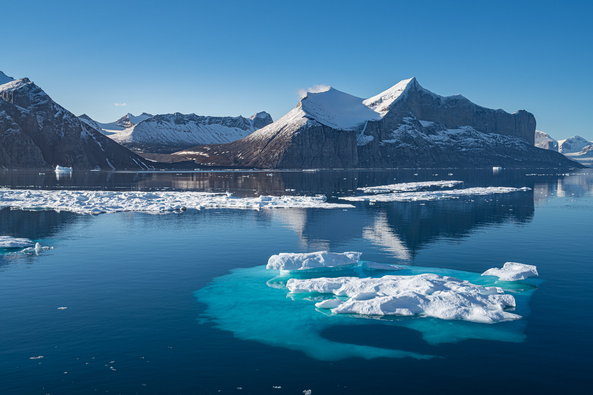
Instead of heading further north, we had some additional time for exploring the many unnamed fjords of Axel Heiberg Island, just west of Ellesmere Island. We spent the night anchoring in one of the bigger - and therefore named - fjords, Mocca Fjord. We could even go for a beautiful early morning hike before breakfast, there.
The Canadian Arctic is a challenging region to navigate. To ensure a safe passage for all vessels, retired icebreaker captains are hired as so called ice masters, basically consultants to the captain. Our ice master had the command of an Arctic icebreaker for over 40 years. In an region, where satellite coverage is spotty, ice masters are also in constant contact to the Canadian Coast Guard, making sure, that the most recent ice updates are available. Chatting with our ice master was extremely interesting.
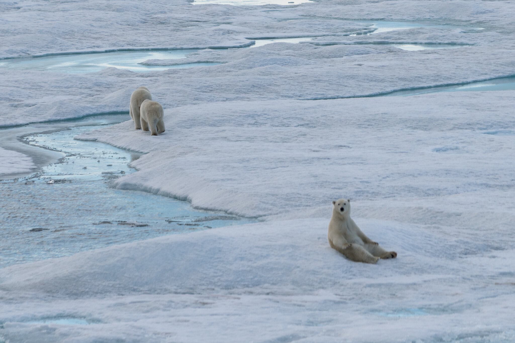
Later that day, we spotted a polar bear mom with two healthy cubs on an ice floe. Our captain stopped the engines of MS Hanseatic and we were drifting silently. The polar bears were not afraid at all and were really interested in this big floating thing next to their floe. Eventually, they decided that we probably didn‘t mean food and were therefore not interesting. As they slowly trotted away, one of our fellow passengers spoke out what we all thought: Stay safe and have a long life! After a final walk on shore, we headed south again.
Cardigan Strait or Hell Gate?
On our way north, Hell Gate was blocked with ice but Cardigan Strait was open. Now, Cardigan Strait was completely clogged, but Hell Gate was open. That shows how quickly the ice situation can change. Hell Gate didn‘t live up to it‘s name and we had a smooth passage despite the strong winds. We even made such a good progress, that we could plan an additional shore landing at Baade Fjord. There, we discovered fossils that originated hundreds of millions of years ago, when Ellesmere Island had a tropical climate.
Later that day, we received information from our ice master, that the icefield up north had indeed moved south and blocked the main fjord of Ellesmere Island. Even the supply vessel had to leave Eureka a day early to avoid the ice. The decision not to venture further north proved right.
Northern Greenland
On our way back to Greenland, we planned to drop our ice master in the tiny town of Grisefjord. He would have been staying in the only motel in town for four days before flying back home. Since this motel had neither a restaurant nor a kitchen, he would have been taking a big lunch box along. We assume, that he wasn‘t too unhappy, when the ice situation prevented us from dropping him there. He will therefore be staying on board for a few more days before flying home to Canada from Ilulissat (Greenland).
Saying goodbye to Canada, we sailed across the stormy waters of Baffin Bay to our first stop in Greenland, Siorapaluk. Siorapaluk has only about 50 inhabitants, but many more dogs. On a warm and calm day, the strong smell of dogs and of the carcasses of hunted animals on the beach was quite challenging. But, then, it should really be that warm in the northernmost settlement of Greenland.
Qaanaaq, our next stop, felt like a big city to us. With 650 inhabitants, there are two supermarkets, a hospital, a school, a retirement home, a church, and even a working internet connection. There is a quite unique story about one of the paintings in the local church. The painting depicts Jesus wearing sandals on his bare feet. The locals felt sympathy for poor Jesus having to wear sandals in the cold Arctic. They therefore painted blue socks on his feet to keep him warm.
Qaanaaq was founded in the 1950s when the people from the town of Thule had to relocate, since the US were expanding their Air Force Base, there. Our next stop was in Old Thule, now a ghost town, next to the Air Force Base. Arriving there at sunrise was a wonderful start into a new day. We took a long walk across the tundra and enjoyed the still frozen fall colored leaves and the few remaining flowers.
Around noon, we arrived at Parker Snow Bay. We could hike for hours across small streams crisscrossing the sandy and muddy flats. At the end of this open glacial valley, there were still some remains of a glacier. What a unique and pleasant place to spend the afternoon.
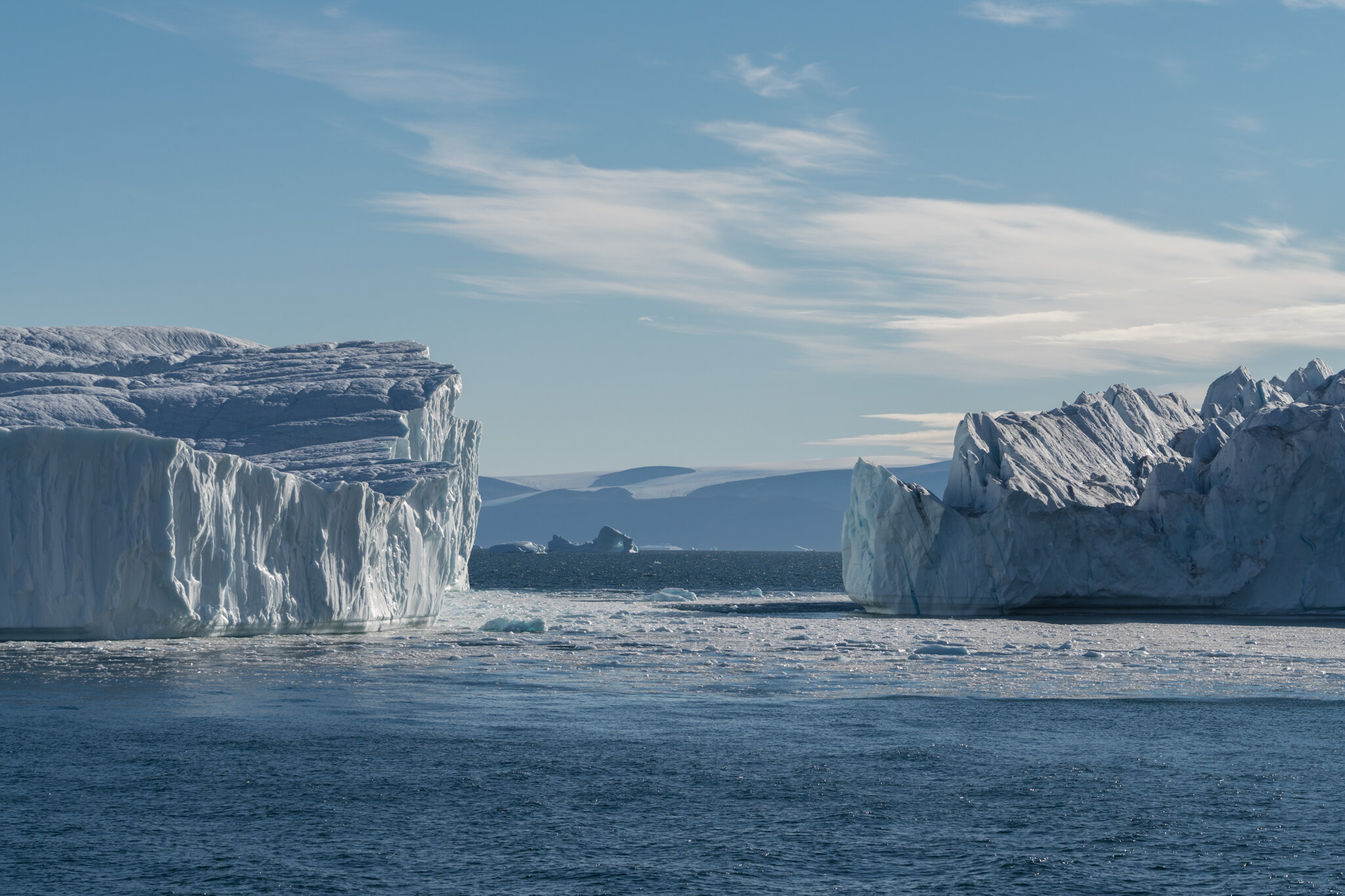
Our expedition day was not over, yet. Just before sunset, we sailed past Cape York. This area is known as iceberg alley due to the many icebergs being grounded in the shallow water. These icebergs are usually breaking off Jakobshavn Glacier in Ilulissat and are then drifting north. They will be grounded around Cape York until enough ice is melted to allow them to float again. Watching hundreds of icebergs in the golden evening sun was just awesome!
Western Greenland
While the midnight sun is a wonderful experience, it prevents the northern lights from being visible. Therefore, the further south we were headed and the later in the season, our chances of experiencing this phenomenon were increasing. And finally, after a sunny day at sea, we could admire the aurora borealis for the first time. Gorgeous!
The towns we were visiting grew increasingly bigger. Uummannaq counts almost 3.000 inhabitants. With its colorful houses on the slopes of Mount Uummannaq, it is often considered one of the most beautiful towns of Greenland. We would certainly agree. Our plan for today was hiking a rocky trail to the home of Santa Clause, or Father Christmas as he is called here. The legend of him spending the summers here goes back to an extremely popular Danish Christmas TV series filmed here. Anyway, we were very happy to eat the Christmas cookies that the crew of MS Hanseatic had been bringing along. While we were enjoying the view, we could hear the loud rumbling noise of icebergs breaking apart in the bay of Uummannaq.
As this amazing expedition was slowly coming to an end, visiting Disko Bay surely was one of the highlights. The plan was to use our tender boats or Zodiacs to go ashore and hike to a viewpoint above Ilulissat Icefjord. However, the ice in the bay was so dense that going ashore was out of question. We were completely happy with this, since Disko Bay is best experienced from the water. And thanks to the additional time, we could even do some more Zodiac cruising around the massive icebergs in the bay. This was the fifteenth and final Zodiac cruise of this trip. With almost no wind, the water was reflecting the icebergs like a mirror.
After the traditional farewell dinner on board, just as we were getting ready to got to bed, the aurora borealis appeared again. This time, the mystical green light was even brighter and more spectacular!
For the first time ever on this trip, MS Hanseatic docked on a pier. Sisimiut is a picturesque town just north of the Arctic Circle. For expedition cruise ships, this an important port of call for restocking the supplies. We enjoyed our time on shore in Sisimiut doing things, we haven’t been doing for weeks: We went shopping for some local artwork and for the famous Qiviut (musk ox wool). But as the trip finally came to an end, we had to start packing our suitcases.
We arrived in Kangerlussuaq at the end of Søndre Strømfjord early next morning. With countless beautiful memories and thousands of photos, we were finally flying home again. We have had the privilege to travel to a region that is inaccessible most of the time. This trip wouldn’t have been possible for the last few years since ice was blocking the narrows between Jones Sound and Norwegian Bay. We still can’t believe how lucky we were. No doubt, we will be back, soon.